I like Boise — it’s a very nice area and city. Panhandle region is completely different, though. More trees & water, as you can see. I love it here. Others only get to come on vacation… but I get to LIVE here! ;-)
Boise was very nice! I was there on a business trip in Sept 200?.
I was so looking forward to some cooler weather and I’ll be darned, they were having a heat wave. It felt just like Alabama (weather wise).
There was an arts and craft festival in a nearby downtown park. There was also some other festival as well. I went to a “concert” a block from my hotel, and heard and saw all kinds of music and dance (a lot of folk dances). It was wonderful.
I had rented a car and I drove around 21 and 75 – was hoping to make it to “Craters of the Moon”. It was before I had a digital camera. I was using my Canon AE1 and I was halfway around before I realized I had either no film in the camera or hadn’t registered the film IN the camera correctly.
I remember passing through Sun Valley, thinking Movie Stars!
By the time I got to Highway 20, it was too late in the day to try and make it to “Craters of the Moon”. The roads (21 especially) were very curvy and you couldn’t go much above 40 MPH. I did see some beautiful scenery and did manage some photos after I got the film into my camera, correctly.
You are lucky to live there. Alabama is beautiful in OTHER ways. But as for me, you just can’t beat mountain scenery.
This is absoutely spectatcular. I have a song that has a video that reminds me of Matt’s trip – even if you do not like the singer or song (I like the song) the video reminds me so much of many of Matt’s photos –
Don…that is a beautiful song!! Thanks for sharing. It’s been a very long time since I heard Pam Tillis (not that I listen to a lot of country music…but enough to know who she is).
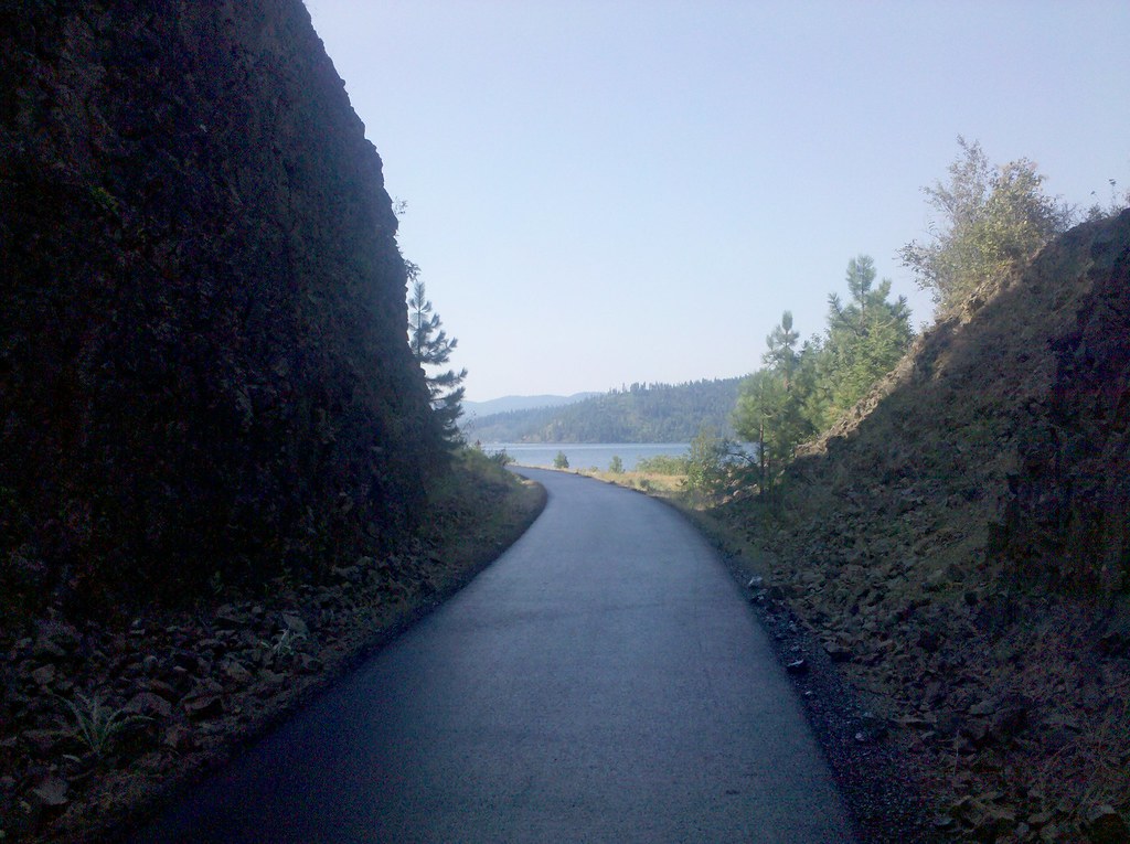
“The Cut”…I have in my minds eye…a train…probably that’s why they needed “the cut”…and probably did it with mostly “manpower”…by hand…I just can’t imagine that much work…but it was done all over the world…
But still the cut is beautiful…it opens up to this…amazing…
Can’t wait to see whats around the bend. Beautiful pictures. I’m thinking this is the best part of the adventure and Lori You are the luckiest you get to live there.
Hey, I just found out about this whole thing a few days ago but I’m hooked! Love what you’re doing Matt! Best wishes. Hey, Does anyone know how his tires are holding up? Did he have to change them at all?
i am following the trek with instructions from candice in alabama who showed me how to see the geographical location via flickr. but it doesnt make sense to me that matt went southwest from rose lake idaho to medimont but then out to harrison and springston (which would take him north again to I-90) but then back down to lacon? at least that’s via the locations posted on flickr. boy, is this confusing. perhaps someone can point this armchair cartographer in the right direction?
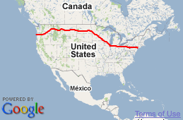
charlie, I don’t remember instructing you, but if you look on the main page of Matt’s blog at “imjustwalkin.com”. Under the “Email me:” link, there will be a box labeled “Here’s my progress so far:” containing a small map of North America, which has a red line marking Matt’s progress. You can click inside this box and as you click it will zoom in for a closer view.
Matt’s father, I think mentioned this several days back.
If Matt cannot post photos on his blog, we can follow his progress via the red line on that map and know that he’s okay and moving along.
yes, you did actually, on a much earlier photo that i did not understand the location designated. you told me how to view the picture on flickr and click on details and it would show the location and latitude/longitude, date taken, etc. btw….thanks. i know there is a map and a red line (thanks Don) but was just confused because i wondered if the photos were posted out of order or something.
which it turns out was the issue. medimont/harrison/springston/harrison/lacon/rockypoint, is how they were posted, which is what threw me off. plus the fact that i forgot to turn on the ‘walking’ part of google maps instead of the ‘driving’ part. but all is well again, for the most part, with the world. thanks.
That's the idea, at least. I'm walking westward from New York City for nine months or so.
If everything goes according to plan, I'll be in Oregon when the clock runs out.
If nothing goes according to plan, maybe I'll end up in Peru or Mongolia or Pennsylvania.
You can read all about the details of my trip
if you're so inclined.

Again – beautiful, again, I’m envious!
I feel like a trip to the Idaho Panhandle is in my future (I’ve been to the Boise area). I’m going to make it happen, someday.
I like Boise — it’s a very nice area and city. Panhandle region is completely different, though. More trees & water, as you can see. I love it here. Others only get to come on vacation… but I get to LIVE here! ;-)
Boise was very nice! I was there on a business trip in Sept 200?.
I was so looking forward to some cooler weather and I’ll be darned, they were having a heat wave. It felt just like Alabama (weather wise).
There was an arts and craft festival in a nearby downtown park. There was also some other festival as well. I went to a “concert” a block from my hotel, and heard and saw all kinds of music and dance (a lot of folk dances). It was wonderful.
I had rented a car and I drove around 21 and 75 – was hoping to make it to “Craters of the Moon”. It was before I had a digital camera. I was using my Canon AE1 and I was halfway around before I realized I had either no film in the camera or hadn’t registered the film IN the camera correctly.
I remember passing through Sun Valley, thinking Movie Stars!
By the time I got to Highway 20, it was too late in the day to try and make it to “Craters of the Moon”. The roads (21 especially) were very curvy and you couldn’t go much above 40 MPH. I did see some beautiful scenery and did manage some photos after I got the film into my camera, correctly.
You are lucky to live there. Alabama is beautiful in OTHER ways. But as for me, you just can’t beat mountain scenery.
Matt you give us the Best shots. Thanks
Cool! First Post today!
That is a great picture. Looks like you have a new path to walk on – Bonus!
Shoot, barely beat out by Candice and Oye!.
By mere seconds Ed….by mere seconds! :)
What lies beyond the bend? Probably a lot of great views so Matt could give us more awesome pictures.
Absolutly beautiful! Have ben following you since day 21 and am certainly enjoying tagging along. Finish Strong!
This is absoutely spectatcular. I have a song that has a video that reminds me of Matt’s trip – even if you do not like the singer or song (I like the song) the video reminds me so much of many of Matt’s photos –
Hope all enjoy the song and video – http://www.youtube.com/watch?v=r-j_U3fA22E
Don, I’ve never liked or disliked Pam Tillis. But I’m open to a lot of different music. Love the song and especially the scenery. Thanks
That was quite appropriate, Don! Beautiful!
Don…that is a beautiful song!! Thanks for sharing. It’s been a very long time since I heard Pam Tillis (not that I listen to a lot of country music…but enough to know who she is).
Same here deanna!
You should name this ‘Just around the Bend’. Awesome as always.
Peace, from Michelle in Providence
Nice nice nice. I just love it.
“The Cut”…I have in my minds eye…a train…probably that’s why they needed “the cut”…and probably did it with mostly “manpower”…by hand…I just can’t imagine that much work…but it was done all over the world…
But still the cut is beautiful…it opens up to this…amazing…
Wow good for you, God Bless and keep going strong!
Can’t wait to see whats around the bend. Beautiful pictures. I’m thinking this is the best part of the adventure and Lori You are the luckiest you get to live there.
Hey, I just found out about this whole thing a few days ago but I’m hooked! Love what you’re doing Matt! Best wishes. Hey, Does anyone know how his tires are holding up? Did he have to change them at all?
i am following the trek with instructions from candice in alabama who showed me how to see the geographical location via flickr. but it doesnt make sense to me that matt went southwest from rose lake idaho to medimont but then out to harrison and springston (which would take him north again to I-90) but then back down to lacon? at least that’s via the locations posted on flickr. boy, is this confusing. perhaps someone can point this armchair cartographer in the right direction?
charlie, I don’t remember instructing you, but if you look on the main page of Matt’s blog at “imjustwalkin.com”. Under the “Email me:” link, there will be a box labeled “Here’s my progress so far:” containing a small map of North America, which has a red line marking Matt’s progress. You can click inside this box and as you click it will zoom in for a closer view.
Matt’s father, I think mentioned this several days back.
If Matt cannot post photos on his blog, we can follow his progress via the red line on that map and know that he’s okay and moving along.
yes, you did actually, on a much earlier photo that i did not understand the location designated. you told me how to view the picture on flickr and click on details and it would show the location and latitude/longitude, date taken, etc. btw….thanks. i know there is a map and a red line (thanks Don) but was just confused because i wondered if the photos were posted out of order or something.
which it turns out was the issue. medimont/harrison/springston/harrison/lacon/rockypoint, is how they were posted, which is what threw me off. plus the fact that i forgot to turn on the ‘walking’ part of google maps instead of the ‘driving’ part. but all is well again, for the most part, with the world. thanks.
Don in TN…Thank You for the link to the River and the Highway, I too like the song, great for road trips.
You have a great view to travel by today… love all the photos…. waiting to see what’s around the bend!
Yikes! and beautiful at the same time. Yikes because of it being so tight and narrow in there are then what lies ahead around the bend is beautiful.
Can you imagine a train going through here? I don’t know which is a tighter squeeze: the main drag in Burke or this!
It’s something of a major engineering feat to have cut this entire path. Watch out for mud/rock slides!
Beautiful shot.
Now this is a path I would not mind walking one day.
Agreed.
Bet after that long stretch of gravel roads.. esp the one that looked like boulders most of the way… this was a God-Send!
right on … For every troubled path we walk….He will provide us with smooth passage when we realy need it the most.
With a shot like this you’re definitely starting to ‘channel’ us through your walk Matt.